+1(727)538-8744
request a quote
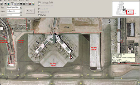
Airfield Inspection GIS: i-AIR®
GIS/GPS Moving Map Technology for Airport Management
NAC's Aviation GIS Solutions allows airport operators to provide greater safety and security for their passengers, while efficiently managing their airport facilities. Geographic information systems (GIS) supports both air- and ground-side operations such as: Flight tracking, Navigation Planning and Design, Operations and Maintenance Security.
Product Brochure
.jpg)
View as
Sort by
Display
per page
")
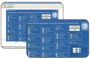
i-AIR®: Integrated Airfield Self-Inspection and Reporting Solution(ESRI)
i-AIR® is a GIS module that can be implemented as a standalone airfield safety management and tracking system or used independently as a GIS airfield safety inspection data collection solution. The moving airfield map allows for accurate and efficient GPS tracking, and preserves historical data in GIS format for report generation and analysis to improve safety and reduce risk.
Call for price

Customer Trust Local Focus - Global Scale


![]()